Tour Zu Fuß Bezirk Kaschau II - Náučný chodník Mestskej časti Košice - Sídlisko KVP - Photo

Náučný chodník Mestskej časti Košice - Sídlisko KVP

Tous les sentiers balisés d’Europe GUIDE+

© OpenStreetMap contributors
Länge
Länge
3 km
Maximale Höhe
Maximale Höhe
326 m
Positive Höhendifferenz
66 m
Km-Effort
Km-Effort  
3,8 km
Min. Höhe
Min. Höhe
273 m
Negative Höhendifferenz
19 m
Boucle
Boucle
Nein
Kennzeichnung
Kennzeichnung
Erstellungsdatum :
2025-02-06 14:53:18.761
Letzte Änderung :
2025-02-06 14:53:18.761

(0 Nachricht)

Zu Fuß
Zu Fuß
51m
Schwierigkeit : Einfach

Scannen Sie diesen QR-Code, um die Tour in der SityTrail-Anwendung zu öffnen

Kostenlosegpshiking-Anwendung

Logo SityTrail SityTrail

IGN / Geografische Institute

SityTrail aus dem App Store herunterladen SityTrail von Google Play herunterladen

Logo SityTrail SityTrail World

Die Welt öffnet sich für Sie

SityTrail aus dem App Store herunterladen SityTrail von Google Play herunterladen SityTrail auf Huawei AppGallery herunterladen

Über SityTrail

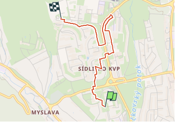
Tour Zu Fuß von 3 km verfügbar auf Kaschauer Landschaftsverband, Kaschau, Bezirk Kaschau II. Diese Tour wird von SityTrail - itinéraires balisés pédestres vorgeschlagen.

Beschreibung

Tour erstellt von Miestny úrad KVP.

no symbols, map depicted on boards is very inaccurate, some board positions are completely off, this relation is best effort to connect all boards in the order intended

Foto-Galerie

Ort

Land:
Slovakia
Region :
Kaschauer Landschaftsverband
Abteilung/Provinz :
Kaschau
Kommune :
Bezirk Kaschau II
Standort:
Košice - mestská časť Sídlisko KVP
Gehen Sie:(UTM)
515787 ; 5395178 (34U) N.

Touren in der Umgebung

Tour Zu Fuß Bezirk Kaschau I - Vrabčie skaly - Photo
Zu Fuß
GUIDE+

Zu Fuß

Einfach
Bezirk Kaschau I, Kaschauer Landschaftsverband, Kaschau, Slovakia
4,9 km | 7,7 km-effort
1h 44min
Ja


Schließen
Meine Abonnements